The Yangtze River Basin
2021-03-05 16:32

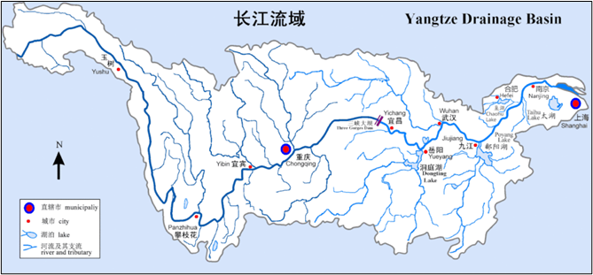
The Yangtze river basin refers to the vast area through which the main and tributaries of the Yangtze river flow. It spans the three economic zones of east, central and west China, and comprises 19 provinces, municipalities and autonomous regions. It is the third largest river basin in the world, with a total area of 1.8 million square kilometers, accounting for 18.8% of China’s land area.
The Yangtze is divided into three parts: The Upper Reaches from the source in Qinghai Province to Yichang in Hubei Province, a distance of some 4,400 kilometers (2,700 miles). This stretch is one of Great beauty, with Wild Mountain ranges, unbroken ravines, unnavigable rapids And rushing torrents. The Three Gorges are included in this section, as is the Sichuan Basin.
The Middle Reaches from Yichang to Hukou at the mouth of Poyang Lake in Jiangxi Province, a distance of about 1,000 kilometers (620 miles). Here, the river Widens and flows through flat, low-lying land and is fed by waters from two huge Lakes, the Dongting and the Poyang. This is the region where the battle against Flooding has been carTied on for centuries, earthen dykes and paved embankments Tell of past and present heroic struggles.
The Lower Reaches from Hukou to the estuary, a distance of some 900 kilometers (560 miles). The landscape in the river’s lower course is typified by a flat delta Plain crisscrossed by canals and waterways, with soil so rich and water so abundant That the region has been known for centuries as the ‘Land of Fish and Rice’.


